
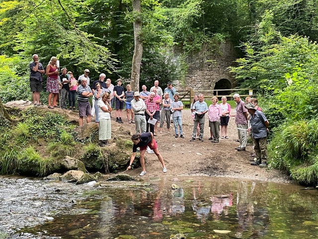
Since 2016, Westcountry Rivers Trust‘s (WRT) Westcountry Citizen Science Investigations (CSI) has been enabling volunteers to collect observational data and conduct water quality tests across the region.
WRT CSI leadership in CaSTCo has demonstrated how citizen science can scale for large-scale regional impact. To date, over 1,700 volunteers have been engaged, contributing to 27,000+ surveys. Surveys include observations of land-use, pollution, wildlife, water quantity and measurements of water quality. The WRT CSI survey was also the first water quality survey data hosted on Cartographer, leading the way for other catchments to share data openly.
As part of CaSTCo, they are further developing innovative ways to test, focusing on both broad and deep engagement, where their insights help highlight potential pollution sources and target further investigation.

The challenge: driving impact at scale and ensuring long-term engagement
When the CaSTCo project began in 2022, the Westcountry Rivers Trust (WRT) Citizen Science Investigations (CSI) scheme had evolved from a grassroots citizen science effort into a more structured and data-driven programme and an inspiration to fledgling community science projects across the country. WRT CSI has, throughout CaSTCo, continued to innovate its programme to respond to community questions, mentor other CaSTCo partners, prototype pollution reporting in the Tamar, and further develop its volunteer management systems at scale, improve report cards, and test new methods. Their efforts have improved data quality and increased regional coverage, significantly enhancing the scheme’s scientific value and broadening community engagement.
Who
- Westcountry Rivers Trust – Project lead
- Tamar CSI Pollution Spotting project – Partner
- Environment Agency – Regulatory oversight, policy integration
Where
Across the South West region, covering Cornwall, Devon, Somerset and West Dorset

Citizen Science Investigations aims
- Create a network of catchment communities that are invested in their local environment.
- Educate and engage people with the water environment.
- Produce data that can be used to target work and identify degrading water bodies.
- Spot pollution events so they can be dealt with as quickly as possible.
27,000+
Surveys completed between 2016 and 2025
650+
Active volunteers
1,700+
People engaged since the scheme’s beginning in 2016
Methodology
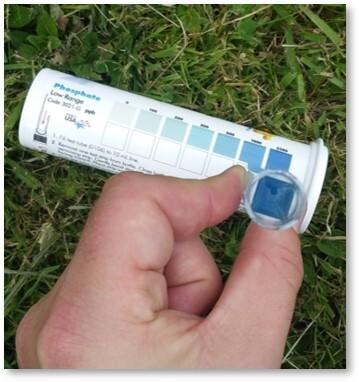
Monitoring methods: Volunteers undertake monthly surveys at the allocated site(s), recording observations of land use, pollution, wildlife, invasive species, and water quantity, alongside measurements of four water quality parameters: temperature, total dissolved solids, phosphate, and turbidity. The methods and equipment required for water quality measurements were selected for their ease of use and relatively low-cost, reducing barriers to participation for volunteers.
These methods are:
- HM Digital TDS-4: Temperature (°C) and Total Dissolved Solids (ppm)
- La Motte low range test strips: Phosphate (ppb)
- Turbidity tube: Turbidity, scale from 240-12 NTU
Training: Conducted in-person or online, with resources updated annually to reflect changes in methodology, health and safety practices, and lessons learned. All volunteers are required to sign up to the WRT volunteer management system and to complete the online training and declaration.
Data usage: Data is stored in Cartographer. Data quality is checked by a trained staff member before being uploaded to the public platform. Volunteers have access to an interactive map of all submitted surveys that can be filtered by time, parameter and location.
The development of the river health scorecards has provided a powerful visual reward for the volunteers’ hard work. To produce a scorecard for a waterbody, at least 12 CSI samples collected over twelve months are uploaded by volunteers to Cartographer, then processed and analysed by the WRT team using R and ArcGIS to generate scores, maps, and visualisations. These are compiled into final scorecards via a mail merge in Word and published online for public access.

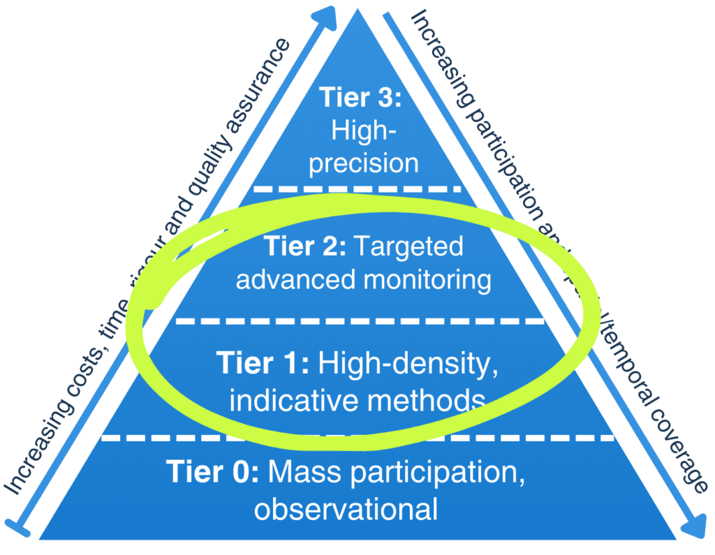
Defining the tiers for volunteers
Most volunteers use Tier 1 tests. In certain instances, more advanced Tier 2 tools are used.
While conducting monthly surveys using the Westcountry CSI method, volunteers are collecting Tier 1, baseline data, which can be used to provide information on the overall state of rivers in the region and can highlight areas where further investigation may be required.
Ensuring volunteers understand the applications of this type of monitoring and when it might be appropriate to transition to Tier 2 methods ensures the programme remains both accessible and scientifically robust. This demonstrates the need for establishing collaborative monitoring schemes that provide opportunities for upskilling to promote volunteer retention.
Mudspotter:
Recent training sessions have helped WRT and partners trial Mud Spotter as part of a broader tiered monitoring strategy:
- Tier 1 – High Density/Community Observations
Volunteers rapidly identify, map, and report sediment issues, expanding the evidence base within 24 hours of rainfall. - Tier 2 – Targeted/Advanced Monitoring
Volunteer reports, combined with developing tools such as the flow mapping prototype developed by CREWW at the University of Exeter, can guide validation sampling at high-risk hotspots. - Tier 3 – Specialist/Regulatory Monitoring
Integrating community data with predictive models can help professionals focus resources on priority sites.
Innovations and insights
Westcountry CSI was the first large-scale citizen science water quality monitoring initiative to be implemented within the UK’s network of Rivers Trusts. It represents a groundbreaking approach to community-led environmental monitoring, empowering volunteers to take an active role in protecting and improving local waterways.
Survey form: The program’s survey form has played a crucial role in fostering a more holistic and collaborative approach to data collection and strategy development. Its design has stood the test of time, requiring little change over the years, demonstrating its effectiveness and reliability in capturing meaningful environmental insights. By ensuring consistency in data gathering, the survey form strengthens the program’s impact and provides a robust foundation for long-term monitoring efforts.
Volunteer Management System: A dedicated Volunteer Management System provides a central platform for the WRT CSI team to manage volunteer data, roles, activity and health and safety, streamlining communication, scheduling, and coordination. Volunteers can manage their own sampling tasks, improving regional coverage, while access to training materials supports consistent data collection and upskilling. Analytics offer insights into participation, helping shape future engagement. Clear communication and visibility into the outputs from their contributions help retain and motivate volunteers. Overall, Assemble enables the CSI programme to scale effectively, support a growing network, and expand volunteering opportunities across WRT’s work.
Trialling new tests and parameters: As part of continuous innovation, scientists and partners work together to trial potential new methods, e.g. BacterisK, Petrifilms and Mud Spotter, enhancing data quality and targeted investigations and offering participants options to answer their local questions.

Mud Spotter: a novel tool
Mud Spotter is an essential tool for identifying and managing fine sediment pollution in rivers, contributing to broader research on water quality. The tool provides valuable data linking suspended sediment with contaminants, which can degrade water quality and impact ecosystem health. By combining Mud Spotter’s surveys with local knowledge from community volunteers, the tool can be adapted to suit the unique needs of specific catchments. The tool’s effectiveness hinges on clear messaging, emphasizing that it supplements existing water quality data, thus maintaining volunteer engagement. Training sessions with volunteers, such as those in Stoke Climsland and the Yealm Estuary group, have underscored the tool’s potential for both identifying point source pollution and informing mitigation efforts.
Training events have played a key role in the tool’s development and application. In Stoke Climsland, volunteers and staff were trained to conduct surveys, providing feedback on the tool’s strengths and limitations. In contrast, the Yealm Estuary group, already familiar with water quality monitoring, intends to use Mud Spotter for more detailed investigations, particularly around overland flow following rainfall. This community-driven approach, combined with local knowledge, allows volunteers to pinpoint areas of concern, aiding landowner engagement and catalyzing change. Both groups have provided feedback that will shape the tool’s ongoing evolution.
The future of Mud Spotter looks promising, with plans to integrate the tool with predictive models developed by Exeter University. By combining predictive data with real-time Mud Spotter surveys, the tool could move beyond basic observation and contribute to specialized monitoring. This collaboration will help focus efforts on high-risk areas, supporting targeted interventions by volunteers, regulators, and landowners to combat fine sediment pollution. Feedback from ongoing training and surveys will continue to refine the tool’s functionality, ensuring it meets the needs of both community volunteers and environmental experts.
Yealm case study
The Yealm Estuary to Moor (YEM) community group began as a group of individuals interested in improving the biodiversity along the length of the Yealm catchment. One of the key goals of the group was to monitor water quality and volunteers began Westcountry CSI in July 2022. Since then, the group has grown to a network of 30 volunteers testing 24 sites monthly across the catchment.
The group has become well established in the South Devon Catchment Partnership and has worked with partners including the University of Plymouth, Environment Agency, DWT and Dartmoor National Park Authority (DNPA) to secure funding for project work. This funding has been used to support multiple activities, including deploying a multi-parameter water quality sonde, working with school groups, developing relationships with landowners, and trialling the Mud Spotter method. Many of the activities listed have been driven by findings generated by Tier 1 reconnaissance monitoring of water quality. The YEM group also participates in various community engagement activities, including annual meetings to present findings, educational work with local schools, and providing community volunteer opportunities such as tree planting and ‘balsam bashing’.
This case study highlights how data collected using the Westcountry CSI programme can be built upon to develop a holistic understanding of the state of the catchment. It also demonstrates how supporting a small community can lead to widespread action across the catchment. The success of the YEM group is well known across South Devon, and their involvement in the South Devon Catchment Partnership and Westcountry CSI scheme has allowed them to share their knowledge and experiences with other groups, including Wild About The River Erme, and Friends of the River Teign.

Bidwell Brook case study
The Bidwell Brook Partnership (BBP) started monitoring water quality using Westcountry CSI in 2023, comprising approximately 20 members who sample at 32 sites across the Bidwell Brook. Their main concerns are contamination from combined sewer overflow (CSO) release, three of which are located along this stretch of river, and the addition of nutrients and sediments from agricultural practice.
After completing one year of monitoring using the Westcountry CSI method, volunteers began to integrate data to locate risk areas where increased phosphate and total dissolved solids (TDS) concentrations were observed. In conjunction with the University of Plymouth (UoP) and Westcountry Rivers Trust (WRT), they used Hanna Checkers to monitor phosphate in high-risk areas. These sites are tested monthly, with additional testing conducted during high rainfall events. Staff at UoP are collecting samples alongside this Tier 2 testing for lab analysis, as well as using the MolEndoTech BacterisK+ system to monitor endotoxin risk, a proxy for bacterial load.
The work of the Bidwell Brook Partnership is now feeding collaboratively into larger projects with SWW and WRT, e.g. Mainstreaming NbS (Ofwat) and several universities with the potential to develop a Living Lab in the catchment. While this brook is relatively small, it experiences many of the pressures experienced across the South West. The lessons learned from this study could be applied across the WRT operational area to support communities in taking action for their local river.
Highlights of the CSI scheme
- An opportunity for people to connect to their local rivers and waterways across the region, allowing them to develop a sense of stewardship and empowering them to make positive change.
- Westcountry CSI volunteers survey hundreds of freshwater locations in Cornwall, Devon, Somerset and West Dorset to monitor their health, biodiversity and water quality.
- By sharing our knowledge with communities in the Westcountry, we are creating credible and competent custodians of the rivers.
- Regular water quality sampling produces robust data, which we can use to identify areas of concern while enabling the citizen scientists to get to know their river, helping to spot positive and negative changes and influence action when needed.
- Catalyst for community groups and evidence-based community action.
Benefits
The CSI program offers significant well-being benefits, fostering a sense of connection between volunteers and their local environment. At its core is a holistic survey tool that acts as both a reconnaissance system and a data-gathering method, capturing a wide range of environmental factors.
Overcoming barriers: The comprehensive approach engages hundreds of volunteers across a wide geographical area, empowering them to monitor their waterways. With low-cost, easily accessible Tier 1 methods, the program removes barriers to participation, allowing individuals from all backgrounds to get involved. This accessibility creates strong impact pathways—by equipping volunteers with the knowledge and confidence to engage with local communities and councils, they can drive real change.
Open-access data: The program’s open-access data model promotes cohesion and fosters a deeper understanding. Several groups, including community groups on the River Yealm and River Luxulyan, use the CSI data available to produce their own reports, which have in turn been used to motivate local councils, communities and the Environment Agency.
Community connections: Connections between volunteers and community groups encourage organic knowledge sharing, often spreading through word of mouth. For example, groups on the River Yealm and River Otter supported new volunteers on the River Erme by sharing their experience, helping them establish a new community group. This cross-catchment collaboration deepens engagement and strengthens community involvement across the region.

Challenges and learnings
Sustaining volunteer engagement: Requires continuous support through training, equipment, and administration—costs that are often underestimated or excluded from project budgets. A dedicated staff team is required to maintain momentum, yet this is rarely factored into short-term funding.
Integrating data into regulatory frameworks: While the data collected by volunteers holds significant value, integrating it into regulatory frameworks remains a hurdle; encouraging organisations like the Environment Agency to recognise and utilise this information is a key ambition. The CSI Team continues to drive this forward, including the development of an online data dashboard that allows for the direct comparison of data collected using Tier 1, 2, and 3 monitoring methods.
Managing volunteer expectations: Volunteer data collected in the Westcountry CSI scheme is used both internally and by external partners in various projects on regional and international scales. Providing volunteers with a clear understanding of how their data can be used for positive change is a vital step in helping them understand its impact. However, more communication is required to share specific examples of where this has happened already and what the outcomes were. This is something WRT is working on as part of the volunteer management and retention strategy.